Two Areas of Tangier Island Now Rated Urgently Critical; VESF Chosen to Provide Sustainable Solution
A group led by the Accomack County Planning District Commission, the Tangier Town Council, local scientists and others have identified two critically-endangered cornerstone areas of Tangier island. The Tangier Town Council has joined with Virginia Ecological Solutions Foundation (VESF) to manage a multi-step plan to save Tangier. Phase 1 of the campaign, seeks a combined 6 million dollars as it kicks off an urgent “Time is of the Essence” call to all those interested in Saving Tangier Island.
The group’s 6 million goal is well within reach and the science-based solutions using nature to redirect the power of nature are attainable. Here’s how you can help.
Consider joining the Save Tangier Island Campaign today with your important contribution. You’ll be helping to save a historic, storied, integral island and its unique community of families, watermen and stewards of the Chesapeake Bay.
Time is clearly not standing still here and the Island residents can’t do this alone. Soon after arriving, most visitors can feel a timeless relationship between the islanders and their surroundings. It’s the way of life that’s existed for centuries on Tangier Island and nowhere else. Tangier Island has a working waterman, real life Jimmy Buffet kinda of feel. It also feels near the edge of fading away.
In reality, for locals and visitors, there is only a short time left to make a difference. Be a part to help preserve all that Tangier is and all Tangier continues to give back. Here’s your chance to help. Please make your donation today.
Are you interested in helping as a volunteer?
We are trying to build our Protect Tangier community. If you are interested in helping, please send your contact information and area of interest or special skills to news@vesf.org
Make Your Donation Today
Why Are These Two Areas The Most Critical?
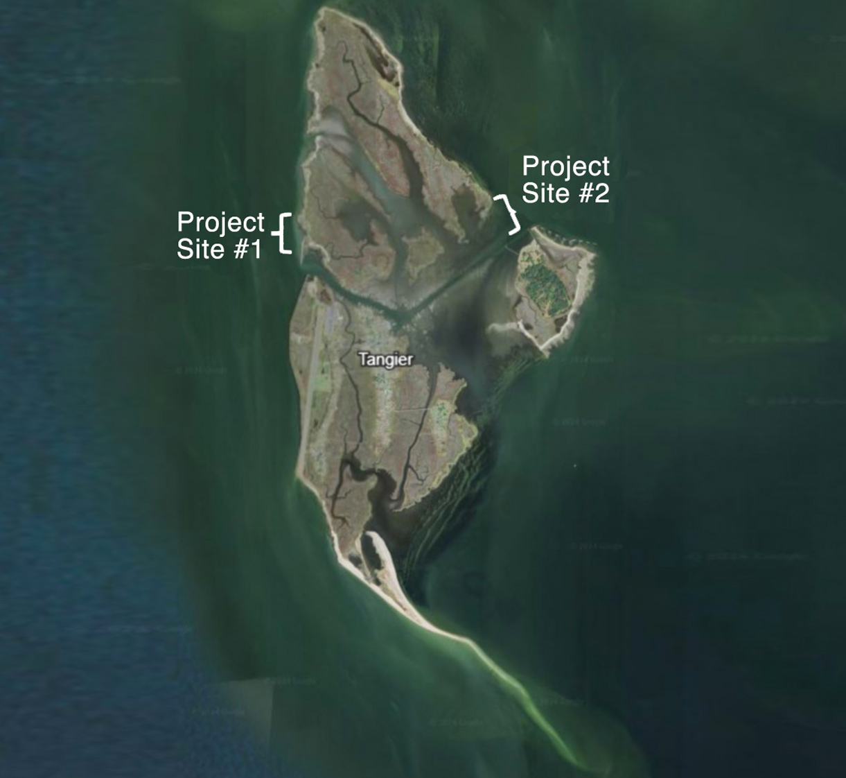
As you can see in Figure 1 at the top of the page, Projects 1 & 2 sit at opposite ends of the Tangier North Channel, which divides the island and provides access to the town. They are the two most extremely vulnerable areas of six critically endangered locations identified by the Accomack County Planning District Commission, county coastal planners, the Mayor, Tangier Town Council members, local scientists, local businesses and non-profit organizations as stakeholders.
Areas of Project 1 are losing 12 meters of land per year. It appears a tidal creek is forming which would compromise the western side of the channel.
Project 2 is losing over 13 meters of land per year. This area provides protection to Tangier harbor, the watermen’s soft crab processing facilities. It is a critical component of the town’s economy.
Dr. Russell Burke answered questions about the urgent need to begin work on both projects and what the significance of raising the needed funds would mean.
Project 1 Critical Issues and Vital Importance to Tangier
Answers provided by Dr. Russell Burke
What is the most dynamic or central element of this plan?
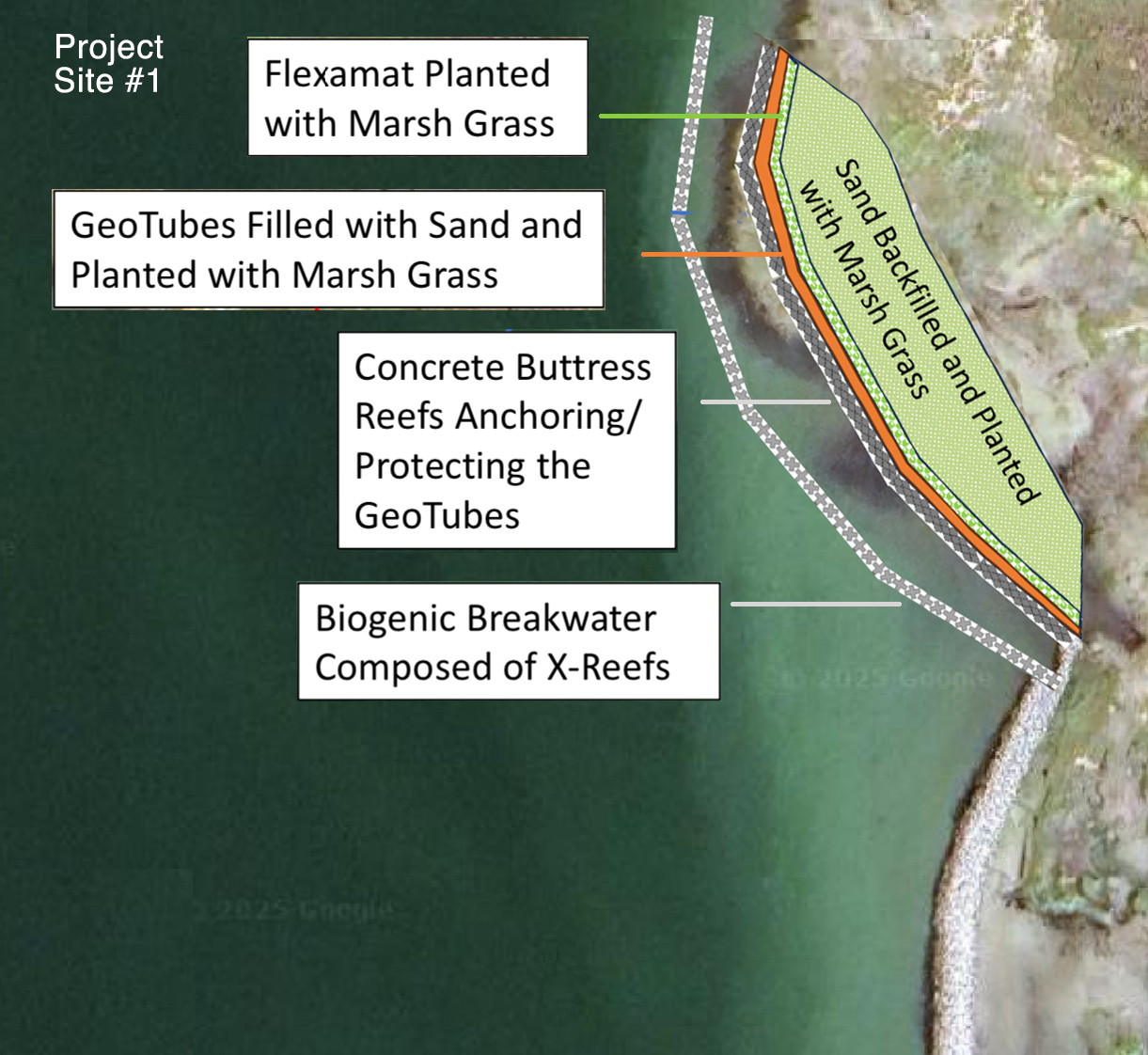
First and foremost, stabilizing the actively-eroding shoreline at this project site is paramount – the concrete buttress reefs will support the sediment-filled GeoTubes, and the Flexamat will ensure containment of the backfilled sand/sediment, along with the planted marsh grasses.
How important is it to reach or exceed the goal of $2.5 million for Project 1?
It is critical that the project receive the requisite funding to procure and install the reinforcing elements of the project design which will stabilize the wetlands at this site, including the placement of sand and/or dredged sediment,
How soon can work begin?
With funding in hand by mid-to-late summer, we could submit the permit application, receive approval, and begin reef fabrication and project material procurement this fall (2025), with construction on site starting spring 2026.
What is the benefit of using natural and nature-based features in this project?
The principal benefits of using natural and nature-based features are (1) nature is able to recover to its previous, undamaged state much faster, and (2) funds only have to be expended once at a project site because the design is specifically geared toward long-term sustainability of wetland habitats
What is the significance of this campaign’s success?
The significance of this campaign’s success is (1) the immediate protection of this portion of Tangier Island and (2) this project will serve as a template for how to preserve, protect, and restore the rest of Tangier Island where marshlands are eroding and land continues to be lost.
Project 2 Critical Issues and Vital Importance to Tangier
Answers provided by Dr. Russell Burke
What is the most dynamic or central element of this plan?
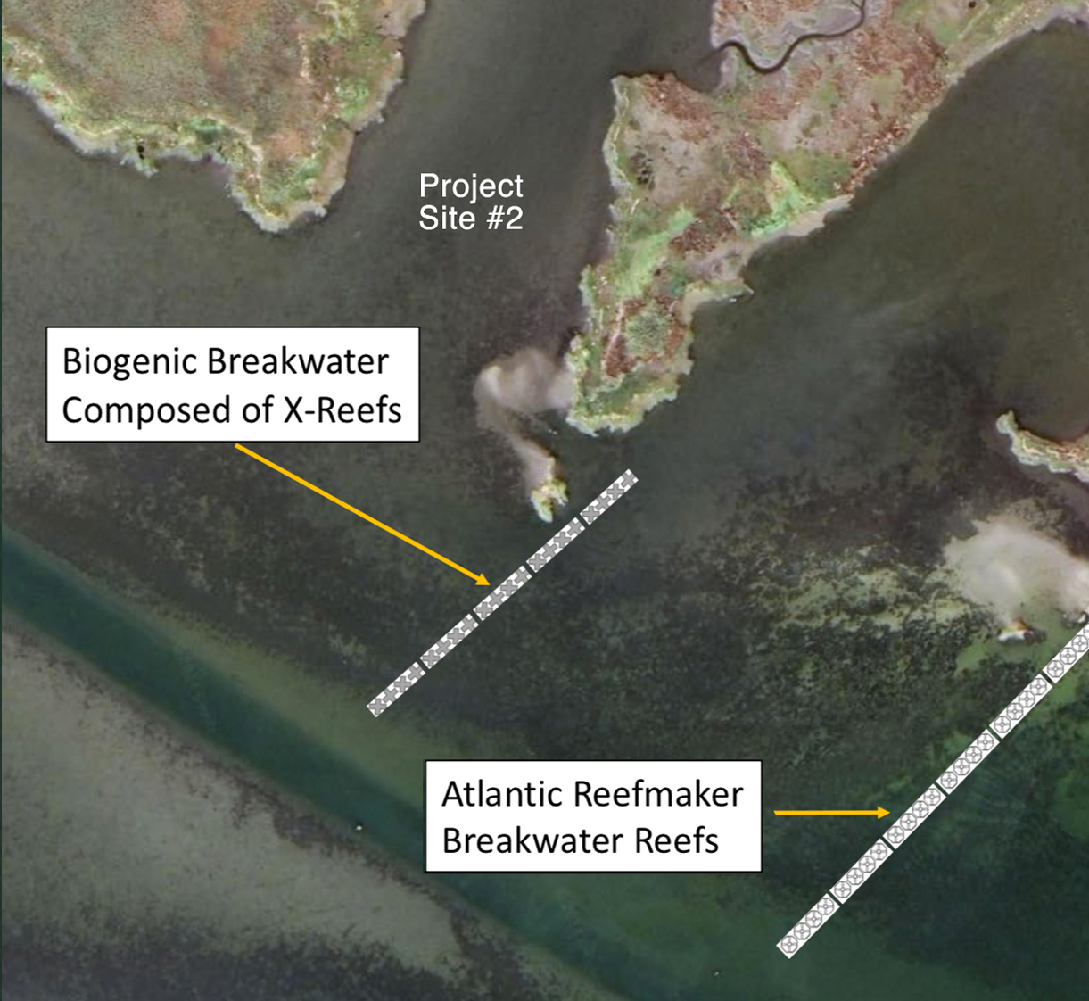
The central element of this plan is wave attenuation (reduction) via concrete reef breakwaters. The precise design reduces the wave energy reaching the wetlands located inshore of the project site and protects the town’s infrastructure on the eastern side of Tangier Island. The secondary benefits will be increased resident oyster/mussel communities on the reefs, and provision of habitat and food for local fishes and crabs
How important is it to reach or exceed the goal of $3.25 million for Project 2?
In order to protect existing wetlands inshore of this project site, offshore reef breakwaters need to be fabricated and installed. Reaching (or exceeding) the fundraising goal is essential for the success of this project due to the large size of the area exposed to wind-generated waves, and the critical town infrastructure currently vulnerable to them during storms.
How soon can work begin?
With funding in hand by mid-to-late summer, we could submit the permit application, receive approval, and begin reef fabrication and project material procurement this fall (2025), with construction on site starting spring 2026.
What is the benefit of using natural and nature-based features in this project?
The principal benefits of using natural and nature-based features are (1) wetland and adjacent upland environments will be able to maintain themselves under a reduced wave energy regime, and (2) funds only have to be expended once at a project site because the design is specifically geared toward long-term sustainability of oyster and fish reef habitats
What is the significance of this campaign’s success?
The significance of this campaign’s success is (1) the immediate protection of this portion of Tangier Island and (2) this project will serve as a template for how to preserve, protect, and restore the rest of Tangier Island while enhancing local fisheries.
How We’re Using Nature to Protect Tangier
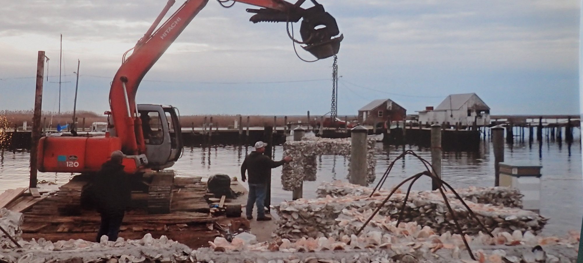
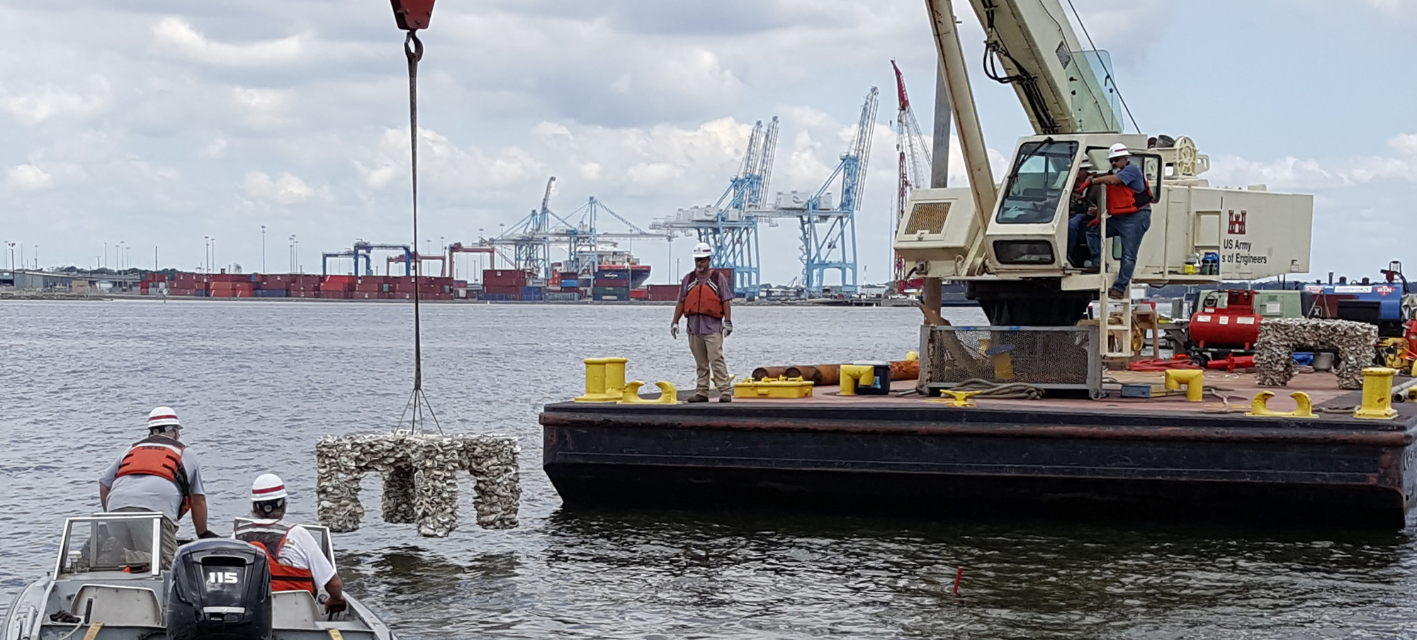
X shaped biogenic (oyster shell layered) will be deployed at each of the first two projects. These reefs attract a greater concentration of new oyster growth. As oyster reefs can grow in height vertically and outpace with sea level rise (Rodriguez et al., 2014), restored oyster reefs are capable of sustained wave attenuation benefits as sea level rises. The reefs act as natural breakwaters, attenuating wave energy from 30-200%, depending on wave height and height of the reef crest (Ferrario et al., 2014). Therefore, our proposed NNBF living shoreline reefs will directly and significantly enhance both the Island and Town of Tangier’s resilience to climate hazards. Oyster reefs also result in sediment deposition shoreward in their lee (Gracia et al., 2017), which assists restored shoreline wetlands by providing enhanced sediment input, enabling them to maintain their elevation in the face of sea level rise (Liu et al. 2021). Photos taken from an similar project at Ft. Norfolk.


